
How to use your Beacon to Beacon Guides
Navigation information
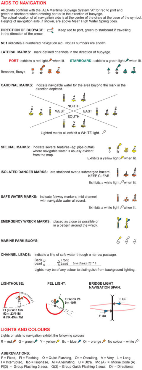
Many aspects of the maps have been designed for local conditions. Although the maps are suitable for navigation under the IALA buoyage system, some
of the symbol standards have been modified for use in Queensland. For example, navigation aid symbols may be shown in similar colours as you would
see out on the water.
Changes in channels and banks: Changes may result in navigation aids being moved from their charted position, altered, removed or new navigation
aids being established. Changes to most navigation aids can be found on the Maritime Safety Queensland website (www.msq.qld.gov.au) under Notice to
Mariners.
Clearances for overhead bridges, cables and pipeline crossings: Shown above Highest Astronomical Tide (HAT). The deepest channel may not always
occur at the clearance height or centre of the crossing. Cable clearances are generally given for the lowest point of sag. Cable TV wire may decrease the
available height on some crossings. Clearances may not be available for all crossings. Maintain a proper lookout. Due to the extent of coverage of the
Beacon to Beacon Guides, waterways crossings clearances and positions may become dated. Should you have any doubts about crossings, contact your
local council or utility company.
Compass bearings: True bearings may be converted to magnetic bearings by applying the compass variation. You can calculate the magnetic declination
for any point when using the maps in the Beacon to Beacon Guides, by visiting the Geoscience Australia website at
http://www.ga.gov.au/oracle/geomag/agrfform.jsp and following the onscreen instructions. The item called “D” is your magnetic variation and the field
“dD” is the rate of annual change.
Dates of soundings: Due to the extent of coverage of the Beacon to Beacon Guides, soundings may become dated. As required, areas are surveyed for
specific projects. Navigation aids are maintained to ensure that when following beacons and buoys, you should generally be in the best water available
but conditions can change frequently so keep a proper lookout. When travelling outside of marked channels, particularly following significant floods,
travel slowly and with a proper lookout (or depth sounder). Where surveys have been taken, sweeping the seabed for obstructions has not been
undertaken.
Damaged or defective aids to navigation or marine infrastructure: Damaged or defective aids may be reported to Maritime Safety Queensland. To
report this, visit the “Contact us” page on the Maritime Safety Queensland website at http://www.msq.qld.gov.au/About-us/How-to-contact-
us/Regions.aspx.
Horizontal datum: GDA94. Compatible with WGS84 for general navigation. Ensure your GPS receiver is set to GDA94 or WGS84 datum. Selective
availability of satellites may degrade your observed position.
Map projection: Universal Transverse Mercator (UTM) Zone 56 with latitude and longitude values shown in degrees and minutes with decimals (for
example, latitude 26° 25.267’ S).
Place names: May not always be official place names. Please check the official place names website at Department of Natural Resources and Mines at
www.dnrm.qld.gov.au/mapping-data/place-names if using any name in a legal context.
Public boat ramps, pontoons and jetties: These destinations are shown. Other facilities may be private (no access) whilst commercial facilities may
charge a fee.
Speed restrictions: Restrictions shown on the maps as an approximate dashed line indicate restrictions for all recreational vessels and/or recreational
vessels over 8m. To determine the speed restriction that applies to your recreational vessel, review the list of gazetted speed restrictions on the Maritime
Safety Queensland website at www.msq.qld.gov.au under waterways > speed limits.
Submarine and overhead cable crossing: Information is based on data provided by the responsible authority and is not guaranteed. At some scales,
not all crossings may be shown over navigable waters. Do not anchor on or near submarine cables or pipelines and always keep a proper lookout.
Vertical Datum: Lowest Astronomical Tide (LAT). Depth ranges in metres.
Always keep a proper lookout when boating.
Look up and live for power and cable crossings that may not be shown on these maps due to scale or recent construction.
CAUTION: depth contours have not been re-surveyed in most areas since the 2011 and 2013 floods.
Exercise care when travelling outside suggested navigation tracks.
Reading the maps
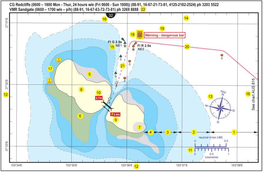
1.
Depth of water over 5m at Lowest Astronomical Tide (LAT).
2.
Depth of water between 2m to 5m at LAT.
3.
Depth of water between 1m to 2m at LAT.
4.
Depth of water between 0m to 1m at LAT.
5.
Depth of water between HWM and 0m at LAT (drying sand banks).
6.
Mangrove areas.
7.
Saltpan areas.
8.
Land areas above the tide.
9.
Overhead power lines with safety clearance shown, where known, above Highest Astronomical Tide (HAT) and generally at the lowest point of sag.
Often marked by signs on the shore. Keep a good lookout overhead at all times for power lines. Due to scale or currency, not all overhead power
lines may be shown.
10.
Where known, clearances in metres of structures (bridges, pipelines) above HAT. The deepest channel may not occur at the point of maximum
clearance.
11.
Scale bar in nautical miles and kilometres. One international nautical mile = 1852m.
12.
Latitude and longitude in degrees and minutes, and at larger scales with decimals of a minute.
13.
Approximate magnetic north.
14.
True north lies along the lines of longitude.
15.
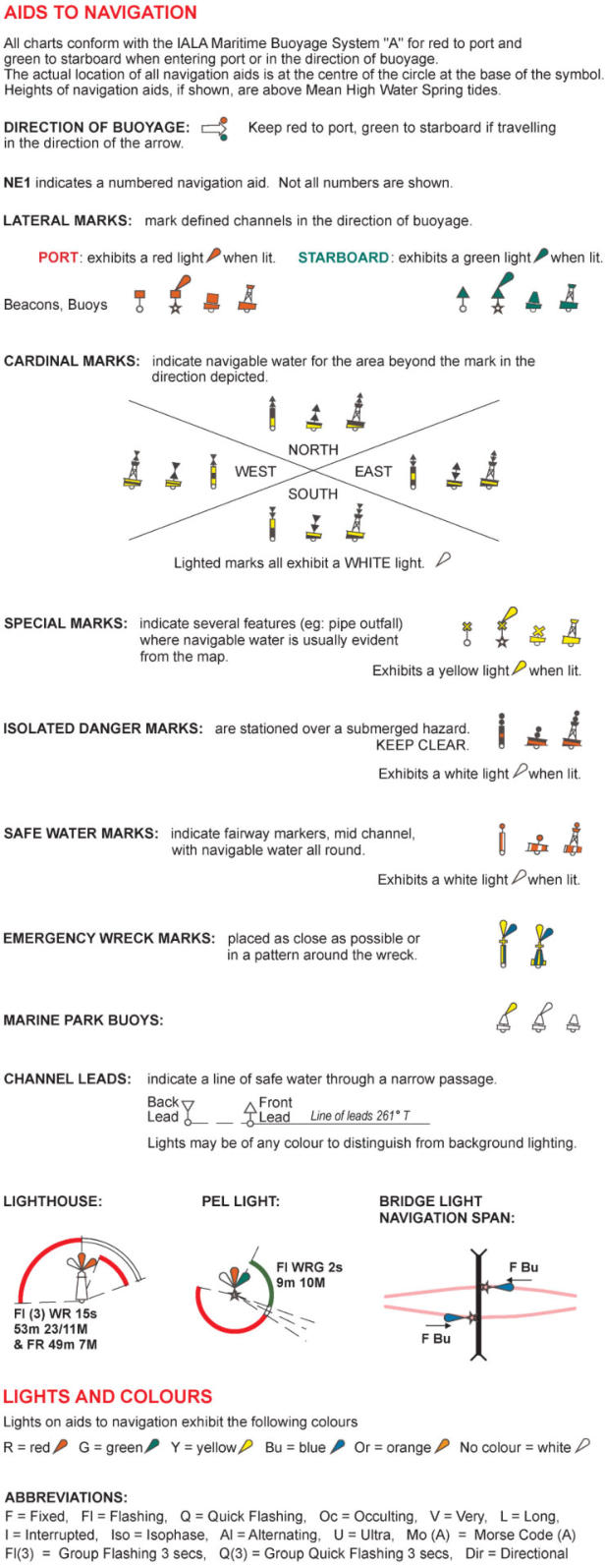
If lit, the light characteristic and if applicable, the name or identifier of the navigation aid.
16.
Adjoining map number or adjoining charts (AUS) published by the Australian Hydrographic Service may be referred to. These maps and charts may
be at different scales.
17.
Anchorage sites.
18.
A life jacket should be worn in or near areas where this symbol is shown or when crossing coastal bars.
19.
Warnings or cautionary notes.
20.
A suggested track intended only to show which side a vessel should pass navigation aids. The track should not be considered as an accurate
prescribed course. Navigation aids shown on maps may not keep pace with changes in channels, depths and banks. A careful lookout should be
maintained at all times.
21.
A suggested track (dashed) where an enforceable speed limit exists for safety or environmental reasons.
22.
Marine rescue services contact details. Note that w/e means weekends, p/h means public holidays.
Legend


- Boating Safety Information
- Required Safety Gear in Queensland
- Boating Safety Stickers
- Queensland Boating Capacity Label
- PWC / Jet ski RideSmart Label
- Lifejackets sticker (red over white)
- Lifejackets sticker (white over red)
- First Aid Kit sticker
- Fire Extinguisher sticker
- Nautical Flags sticker
- 27MHz Marine Radio Sticker Pack
- VHF Marine Radio Sticker Pack
- Safety Equipment Sticker Pack
- No Smoking sticker
- Smoking Area sticker
- 50:1 Fuel to Oil Ratio sticker
- 100:1 Fuel to Oil Ratio sticker
- Navigation Markers sticker
- How to use a VHF marine radio
- Volunteer Marine Rescue Organisations


- Rain Radars
- Satellite Images
- Synoptic Chart
- Coastal Waters Forecast
- Capricornia Coastal Waters Forecast: St Lawrence to Burnett Heads
- Hervey Bay Waters Forecast
- Fraser Island Coastal Waters Forecast: Sandy Cape to Double Island Point
- Sunshine Coast Waters Forecast: Double Island Point to Cape Moreton
- Moreton Bay Forecast
- Gold Coast Waters Forecast: Cape Moreton to Point Danger
- Current Warnings for Queensland

Navigation information
Many aspects of the maps have been designed for local conditions. Although the maps are suitable for
navigation under the IALA buoyage system, some of the symbol standards have been modified for use
in Queensland. For example, navigation aid symbols may be shown in similar colours as you would see
out on the water.
Changes in channels and banks: Changes may result in navigation aids being moved from their
charted position, altered, removed or new navigation aids being established. Changes to most
navigation aids can be found on the Maritime Safety Queensland website (www.msq.qld.gov.au) under
Notice to Mariners.
Clearances for overhead bridges, cables and pipeline crossings: Shown above Highest
Astronomical Tide (HAT). The deepest channel may not always occur at the clearance height or centre
of the crossing. Cable clearances are generally given for the lowest point of sag. Cable TV wire may
decrease the available height on some crossings. Clearances may not be available for all crossings.
Maintain a proper lookout. Due to the extent of coverage of the Beacon to Beacon Guides, waterways
crossings clearances and positions may become dated. Should you have any doubts about crossings,
contact your local council or utility company.
Compass bearings: True bearings may be converted to magnetic bearings by applying the compass
variation. You can calculate the magnetic declination for any point when using the maps in the Beacon
to Beacon Guides, by visiting the Geoscience Australia website at
http://www.ga.gov.au/oracle/geomag/agrfform.jsp and following the onscreen instructions. The item
called “D” is your magnetic variation and the field “dD” is the rate of annual change.
Dates of soundings: Due to the extent of coverage of the Beacon to Beacon Guides, soundings may
become dated. As required, areas are surveyed for specific projects. Navigation aids are maintained to
ensure that when following beacons and buoys, you should generally be in the best water available but
conditions can change frequently so keep a proper lookout. When travelling outside of marked
channels, particularly following significant floods, travel slowly and with a proper lookout (or depth
sounder). Where surveys have been taken, sweeping the seabed for obstructions has not been
undertaken.
Damaged or defective aids to navigation or marine infrastructure: Damaged or defective aids may
be reported to Maritime Safety Queensland. To report this, visit the “Contact us” page on the Maritime
Safety Queensland website at http://www.msq.qld.gov.au/About-us/How-to-contact-us/Regions.aspx.
Horizontal datum: GDA94. Compatible with WGS84 for general navigation. Ensure your GPS receiver
is set to GDA94 or WGS84 datum. Selective availability of satellites may degrade your observed
position.
Map projection: Universal Transverse Mercator (UTM) Zone 56 with latitude and longitude values
shown in degrees and minutes with decimals (for example, latitude 26° 25.267’ S).
Place names: May not always be official place names. Please check the official place names website at
Department of Natural Resources and Mines at www.dnrm.qld.gov.au/mapping-data/place-names if
using any name in a legal context.
Public boat ramps, pontoons and jetties: These destinations are shown. Other facilities may be
private (no access) whilst commercial facilities may charge a fee.
Speed restrictions: Restrictions shown on the maps as an approximate dashed line indicate
restrictions for all recreational vessels and/or recreational vessels over 8m. To determine the speed
restriction that applies to your recreational vessel, review the list of gazetted speed restrictions on the
Maritime Safety Queensland website at www.msq.qld.gov.au under waterways > speed limits.
Submarine and overhead cable crossing: Information is based on data provided by the responsible
authority and is not guaranteed. At some scales, not all crossings may be shown over navigable waters.
Do not anchor on or near submarine cables or pipelines and always keep a proper lookout.
Vertical Datum: Lowest Astronomical Tide (LAT). Depth ranges in metres.
Always keep a proper lookout when boating.
Look up and live for power and cable crossings that may not be shown on these maps due to
scale or recent construction.
CAUTION: depth contours have not been re-surveyed in most areas since the 2011 and 2013
floods.
Exercise care when travelling outside suggested navigation tracks.
Reading the maps
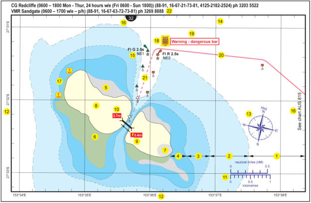
1.
Depth of water over 5m at Lowest Astronomical Tide (LAT).
2.
Depth of water between 2m to 5m at LAT.
3.
Depth of water between 1m to 2m at LAT.
4.
Depth of water between 0m to 1m at LAT.
5.
Depth of water between HWM and 0m at LAT (drying sand banks).
6.
Mangrove areas.
7.
Saltpan areas.
8.
Land areas above the tide.
9.
Overhead power lines with safety clearance shown, where known, above Highest Astronomical
Tide (HAT) and generally at the lowest point of sag. Often marked by signs on the shore. Keep a
good lookout overhead at all times for power lines. Due to scale or currency, not all overhead
power lines may be shown.
10.
Where known, clearances in metres of structures (bridges, pipelines) above HAT. The deepest
channel may not occur at the point of maximum clearance.
11.
Scale bar in nautical miles and kilometres. One international nautical mile = 1852m.
12.
Latitude and longitude in degrees and minutes, and at larger scales with decimals of a minute.
13.
Approximate magnetic north.
14.
True north lies along the lines of longitude.
15.
If lit, the light characteristic and if applicable, the name or identifier of the navigation aid.
16.
Adjoining map number or adjoining charts (AUS) published by the Australian Hydrographic
Service may be referred to. These maps and charts may be at different scales.
17.
Anchorage sites.
18.
A life jacket should be worn in or near areas where this symbol is shown or when crossing
coastal bars.
19.
Warnings or cautionary notes.
20.
A suggested track intended only to show which side a vessel should pass navigation aids. The
track should not be considered as an accurate prescribed course. Navigation aids shown on
maps may not keep pace with changes in channels, depths and banks. A careful lookout should
be maintained at all times.
21.
A suggested track (dashed) where an enforceable speed limit exists for safety or environmental
reasons.
22.
Marine rescue services contact details. Note that w/e means weekends, p/h means public
holidays.
Legend


How to use your Beacon to Beacon Guides


- Boating Safety Information
- Required Safety Gear in Queensland
- Boating Safety Stickers
- Queensland Boating Capacity Label
- PWC / Jet ski RideSmart Label
- Lifejackets sticker (red over white)
- Lifejackets sticker (white over red)
- First Aid Kit sticker
- Fire Extinguisher sticker
- Nautical Flags sticker
- 27MHz Marine Radio Sticker Pack
- VHF Marine Radio Sticker Pack
- Safety Equipment Sticker Pack
- No Smoking sticker
- Smoking Area sticker
- 50:1 Fuel to Oil Ratio sticker
- 100:1 Fuel to Oil Ratio sticker
- Navigation Markers sticker
- How to use a VHF marine radio
- Volunteer Marine Rescue Organisations


- Rain Radars
- Satellite Images
- Synoptic Chart
- Coastal Waters Forecast
- Capricornia Coastal Waters Forecast: St Lawrence to Burnett Heads
- Hervey Bay Waters Forecast
- Fraser Island Coastal Waters Forecast: Sandy Cape to Double Island Point
- Sunshine Coast Waters Forecast: Double Island Point to Cape Moreton
- Moreton Bay Forecast
- Gold Coast Waters Forecast: Cape Moreton to Point Danger
- Current Warnings for Queensland

Navigation information
Many aspects of the maps have been designed for local
conditions. Although the maps are suitable for
navigation under the IALA buoyage system, some of the
symbol standards have been modified for use in
Queensland. For example, navigation aid symbols may
be shown in similar colours as you would see out on
the water.
Changes in channels and banks: Changes may result
in navigation aids being moved from their charted
position, altered, removed or new navigation aids being
established. Changes to most navigation aids can be
found on the Maritime Safety Queensland website
(www.msq.qld.gov.au) under Notice to Mariners.
Clearances for overhead bridges, cables and
pipeline crossings: Shown above Highest Astronomical
Tide (HAT). The deepest channel may not always occur
at the clearance height or centre of the crossing. Cable
clearances are generally given for the lowest point of
sag. Cable TV wire may decrease the available height on
some crossings. Clearances may not be available for all
crossings. Maintain a proper lookout. Due to the extent
of coverage of the Beacon to Beacon Guides,
waterways crossings clearances and positions may
become dated. Should you have any doubts about
crossings, contact your local council or utility company.
Compass bearings: True bearings may be converted to
magnetic bearings by applying the compass variation.
You can calculate the magnetic declination for any
point when using the maps in the Beacon to Beacon
Guides, by visiting the Geoscience Australia website at
http://www.ga.gov.au/oracle/geomag/agrfform.jsp and
following the onscreen instructions. The item called “D”
is your magnetic variation and the field “dD” is the rate
of annual change.
Dates of soundings: Due to the extent of coverage of
the Beacon to Beacon Guides, soundings may become
dated. As required, areas are surveyed for specific
projects. Navigation aids are maintained to ensure that
when following beacons and buoys, you should
generally be in the best water available but conditions
can change frequently so keep a proper lookout. When
travelling outside of marked channels, particularly
following significant floods, travel slowly and with a
proper lookout (or depth sounder). Where surveys have
been taken, sweeping the seabed for obstructions has
not been undertaken.
Damaged or defective aids to navigation or marine
infrastructure: Damaged or defective aids may be
reported to Maritime Safety Queensland. To report this,
visit the “Contact us” page on the Maritime Safety
Queensland website at
http://www.msq.qld.gov.au/About-us/How-to-contact-
us/Regions.aspx.
Horizontal datum: GDA94. Compatible with WGS84 for
general navigation. Ensure your GPS receiver is set to
GDA94 or WGS84 datum. Selective availability of
satellites may degrade your observed position.
Map projection: Universal Transverse Mercator (UTM)
Zone 56 with latitude and longitude values shown in
degrees and minutes with decimals (for example,
latitude 26° 25.267’ S).
Place names: May not always be official place names.
Please check the official place names website at
Department of Natural Resources and Mines at
www.dnrm.qld.gov.au/mapping-data/place-names if
using any name in a legal context.
Public boat ramps, pontoons and jetties: These
destinations are shown. Other facilities may be private
(no access) whilst commercial facilities may charge a
fee.
Speed restrictions: Restrictions shown on the maps as
an approximate dashed line indicate restrictions for all
recreational vessels and/or recreational vessels over
8m. To determine the speed restriction that applies to
your recreational vessel, review the list of gazetted
speed restrictions on the Maritime Safety Queensland
website at www.msq.qld.gov.au under waterways >
speed limits.
Submarine and overhead cable crossing: Information
is based on data provided by the responsible authority
and is not guaranteed. At some scales, not all crossings
may be shown over navigable waters. Do not anchor on
or near submarine cables or pipelines and always keep
a proper lookout.
Vertical Datum: Lowest Astronomical Tide (LAT). Depth
ranges in metres.
Always keep a proper lookout when boating.
Look up and live for power and cable crossings that
may not be shown on these maps due to scale or
recent construction.
CAUTION: depth contours have not been re-
surveyed in most areas since the 2011 and 2013
floods.
Exercise care when travelling outside suggested
navigation tracks.
Reading the maps
1.
Depth of water over 5m at Lowest Astronomical
Tide (LAT).
2.
Depth of water between 2m to 5m at LAT.
3.
Depth of water between 1m to 2m at LAT.
4.
Depth of water between 0m to 1m at LAT.
5.
Depth of water between HWM and 0m at LAT
(drying sand banks).
6.
Mangrove areas.
7.
Saltpan areas.
8.
Land areas above the tide.
9.
Overhead power lines with safety clearance
shown, where known, above Highest Astronomical
Tide (HAT) and generally at the lowest point of sag.
Often marked by signs on the shore. Keep a good
lookout overhead at all times for power lines. Due
to scale or currency, not all overhead power lines
may be shown.
10.
Where known, clearances in metres of structures
(bridges, pipelines) above HAT. The deepest
channel may not occur at the point of maximum
clearance.
11.
Scale bar in nautical miles and kilometres. One
international nautical mile = 1852m.
12.
Latitude and longitude in degrees and minutes,
and at larger scales with decimals of a minute.
13.
Approximate magnetic north.
14.
True north lies along the lines of longitude.
15.
If lit, the light characteristic and if applicable, the
name or identifier of the navigation aid.
16.
Adjoining map number or adjoining charts (AUS)
published by the Australian Hydrographic Service
may be referred to. These maps and charts may
be at different scales.
17.
Anchorage sites.
18.
A life jacket should be worn in or near areas where
this symbol is shown or when crossing coastal
bars.
19.
Warnings or cautionary notes.
20.
A suggested track intended only to show which
side a vessel should pass navigation aids. The
track should not be considered as an accurate
prescribed course. Navigation aids shown on
maps may not keep pace with changes in
channels, depths and banks. A careful lookout
should be maintained at all times.
21.
A suggested track (dashed) where an enforceable
speed limit exists for safety or environmental
reasons.
22.
Marine rescue services contact details. Note that
w/e means weekends, p/h means public holidays.
Legend

How to use your Beacon to Beacon Guides


